Around Memorial day a friend of Dick's came up to the cabin site to "witch" for water. He's done a lot of it around Melrose and it didn't take him long to "witch" veins as well as his preferred site to drill the next hole.
Check these first set of pictures.
This picture is looking east. You can see part of the drain field and in the lower left and upper right you can see the white flags designating the width of a water vein.

This is a picture looking at the south side of the cabin site. This and the next picture will show you a rock in the center of the background. Near it are three white flags. This is the location suggested for a well site.

A closer picture of the flags and the rock.

Here's part of the crew that was up here; Matt with Kyla, John, Dick, Floyd, Nick, and John

Here a second set of random pictures from when Sue and I were up this past week. We were able to "ATV" anywhere we wanted, so the water has gone down significantly. I would still like to fly over the area from the west side of the county to our side just to look at the ditches and rivers draining this area. Maybe I can take some pictures as well.
We painted the locator rock orange so it can't be confused with any other. Since it is pretty dry in the area now, Floyd thought Bruce might be able to back his rig next to the rock and dig the third hole. I talked to Bruce last night. His daughter is getting married August 22nd and between now and then he has some work to wrap up. After the wedding he said he would give Floyd a call and they can go out to the cabin and decide when Bruce could get started. Assuming it was dry enough, Floyd thought Bruce would be able to back up to the site without moving any trees and without having to add fill/gravel . . . cross your fingers.
I reloaded the five trail cams; one by the crossing, one by the pond, one south 0f the cabin, one northwest of Matt's stand and one between Matt's and John's stand.
Here are some additional pictures:
This is looking southeast at the east end of the 80 looking towards Matts stand. I'm trying to show the food plot from last year. The vegetation is clearly different from what is on the rest of the area. I just don't know if it will attract the deer. The trail cam is on the right side of this opening as you are turning south so it should be able to show us.

Here's the rock with blaze orange paint. I just thought it be easy to describe for anyone not familiar with the area. I also painted the cabin corner stakes blaze orange as well thinking it might be easier to see with the web cam.

I took this picture for a couple of reasons. The first was it serves as a fair indicator about how much water is in the area. The second was to show all the tracks around the pond. These were mostly deer tracks.

Here's Susan on the ATV. Behind her is a trail cam looking south across the pond. It will be interesting to see what pictures we get from this. With regular batteries the camera will take pictures for about two months.

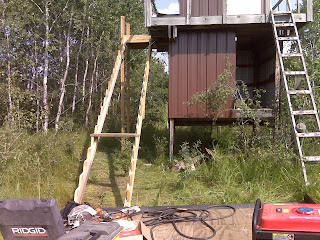
Here's Matt's stand and the progress of adding a stairs. We would also like to do this with John's stand. We are hoping two build one or two additional stands before deer season.
Sue and I also mowed the grass and put some oats in the feeder by the cabin. We mowed in front of the feeder to make it easier to see from the web cam.

Sue and I also mowed the grass and put some oats in the feeder by the cabin. We mowed in front of the feeder to make it easier to see from the web cam.
So . . . that's the report. I'm hopefull that Bruce will soon be able to drill the third hole. I'm also hopeful, as I'm sure you are, that third time's a charm. If you have any questions, please give me a call or e-mail.
